RAJSHAHI DIVISION – 8DISTRICTS


                        8 DISTRICTS OF RAJSHAHI DIVISION

Rajshahi-Division

  1. Rajshahi District:Rajshahi-district


Rajshahi is one of the ancient district of Bangladesh.It is situated on the bank of river Padma which seperates the landscapes of India and Bangladesh.The district Rajshahi commenced on as administrative unit in 1772 based on the jamindary of Rajshahi.Rajshahi district police is composed of 9 thanas and 5 investigation centers.The police stations are Poba,Godabari,Tanore,Mohonpur,Puthia,Baghmara,Durgapur,Charghat and Bagha. Personnel of Rajshahi district police has a luminous history of patriotism in 1971. The Rajshahi district police defended the Pakistan army at 27 March 1971 with their light arms at the very beginning of liberation war.Total 18 police personnel laid down their lives in this war.The then DIG Mamun Mahmud of Rajshahi range and SP Shah Abdul Mazid became the first target of Pakistan army and sacrificed  their lives for their motherland at the very beginning of liberation war in 1971.

2. Chapainawabganj District:

Chapainawabganj-Map

Established in 1984 in the northern joint of Bangladesh, Chapainawabganj district is under Rajshahi division. Once the district was under the rule of Gour king and the historical Sona mosque, Tohakhana and the cemetery of Captain Bir Srestho Mohiuddin Jahangir are located here. This district has a land port and also well known for mango, silk and Gomvira, a traditional folk song. There are two circle offices, five police stations, a police out post, two investigation centers and a police check post in this district. The police stations are Nababganj,Shibganj,Gomostapur,Nachol and Volahat.

3. Natore District:

natore

Natore district is situated on the north-west side of Bangladesh in Rajshahi division. It was the headquarter of Rajshahi district from 1769-1825. It was declared as district in 1984. The total area of this district is 1896.05 sq km. The office of Superintendent of Police is situated at Hazra Natore of sadar Thana. There are seven police stations-Natore Sadar, Singra, Baghatipara, Noldangha, Boraigram, Gurudaspur and Lalpur under two Circles — Natore and Boraigram. There are two investigation centers and two police outposts in this district.

4. Naogaon District:

NAOGAONNaogaon district police has started functioning in 1984. Covering an area of 3435.67 sq km, Naogaon is renowned for many tourist spots including Sumpur Bihar and Rabindra Kachari at Parishar.The district police has 11 police stations, three circles, three police outposts, one investigation center and one police camp. The police stations are Naogaon sadar, Raninagar, Atraei, Bodolgasi, Mohadevpur, Niamotpur, Manda, Potnitola, Dhamuirhat, Sapahar and Porsha.

5. Bogra District:

BograBogra is one of the oldest towns in northern Bangladesh under Rajshahi Division. The area of the town is approximately 71.56 sq km and it is about 10 km away from Mahasthangarh – the earliest capital city of Bangladesh, formerly known as Pundravardhana. Bogra district police comprises office of the Superintendent of Police, two circle ASP offices, twelve police stations, one district detective branch, four police investigation centers, ten outposts and one In-service training centre. The police stations are Bogra sadar,Shibganj, Shonatola, Gabtoli, Shariakandi, Dhunot, Sherpur, Nandigram, Adamdighi, Dhubcharia, Kahalu and Shahjahanpur. The formal journey of Bogra district police began with the joining of Major William Whiler Home as the first SP on 12.01.1875. During the British rule 25 SPs served here and during the Pakistani rule another 21 SPs served in Bogra. Mr. SM Awlad Hossain, ppm, worked as the first SP of independent Bangladesh. Bogra district police played a glorious role in the liberation War 1971. A stage named “Masir Uddin Mancha” has been established in remembrance of the police members who laid down their lives in 1971.

6. Pabna District:

pabna-editedPabna is a district in north-western part of Bangladesh. It is the southern most district of Rajshahi division having an area of 2,371.50 sqkm, under 9 upazillas. Bangladesh mental Hospital, Pabna is a renowned hospital in Bangladesh beside Pabna main town. It has 11 police stations, 7 police outposts, 8 camps and 4 police investigation centers. The Police stations are Pabna, Eshordi, Atghoria, Chatmohor, Vhangura, Faridpur, Sujanagor, Bera, Shathia, Ataeikula and Aminpur. In 1971, Pabna district police was the first to protest against the Pakistan occupation Army. A total of 34 members of Pabna district police sacrificed their lives in their fight against Pak army in 1971.

7. Sirajganj District:

sirajganj-mapSirajganj, a part of Rajshahi division and having 2497.92 sqkm area, was established in 1984 and it is surrounded by Bogra district on the North, Tangail and Jamalpur districts on the west. The office of district Superintendent of Police super is situated at Ambagan in Sadar Thana. There are 12 police stations here: 1) Sirajganj Sadar 2) Belkuchi 3) Chauhali 4) Kamarkand 5) Kazipur 6) Raiganj 7) Shahjadpur 8) Tarash 9) Ullapara 10) Enayetpur 11) Salanga 12) Bangabandhu Setu West. The district has 3 police circles: Sirajganj, Shahjadpur and Raiganj, 4 police outposts and 2 police camps.

8. Joypurhat District:

map-joypurhat

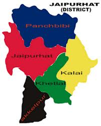
Situated on the north-western region of Bangladesh, Joypurhat is surrounded by Dinajpur on the North, Gaibandha and Bogra on the East and Naogaon on the South. It was turned into a district in 1984 and has an area of 956.44 sqkm. Joypurhat has 1 police circle, 5 police stations — Joypurhat, Panchbibi, Khetlal, Akkelpur and Kalai, 2 police outposts, 1 traffic unit.


CHITTAGONG DIVISION – 11 DISTRICTS

11 DISTRICTS OF CHITTAGONG DIVISION

Chittangong Division1

  1. Chittagong District:

Chittangong DivisionChittagong, established in 1666 including three hill districts, is one of the oldest and biggest districts in Bangladesh with an area of 5157 sq km. It has 14 upazilas, 16 police stations, 04 circles, 08 investigation centers, 08 police outposts, 01 permanent policecamp, 15 temporary Police camps. A proactive, public-oriented solution-based community policing strategy gave a fruitful result in maintaining law and order situation. Chittagong district police administration is divided into four circles. It has  16 police stations: Mirershorai, Sitakondo, Sandip, Fatikshori, Vuspur, Hathajari, Raojan, Rangunia, Patia, Boalkhali, Chondonaish, Anwaara, Bashkhali, Satkania, Lohagora and Zorargonj.

2. Comilla District:

comilla

This district was established as Tripura district in 1790. It was renamed Comilla in 1960. Comilla is a district of Bangladesh located about 100 kilometers south-east of Dhaka. Comilla district police has a rich history in terms of serving the people. It has been operational for a long time and with time has gained quite a legacy. Munshi Kabiruddin, the suprintendent of Comilla district police in 1971, along with his RI Abdul Halim and his son Mukul and Bakul are recognized to be the first martyrs of the war for independence. It is one of the most densely populated districts in the country and in order to cover all the regions in the district, the district police has divided itself into 16 police stations. The police stations are Kotowali model, Sadar dakkhin, Daudkandi model, Chandina, Muradnagar, Choddogram, Debiddar, Burichang, Laksham, Nangolkot, Borura, Bipara, Homna, Titas, Monohorganj and Meghna. Five of these stations are in regions that are located near the Bangladesh-India border. The eastern wing of Bangladesh highway police is located in Comilla, which has the responsibility of protecting vehicles and travelers from highway robbery. They also monitor the highway for any speeding vehicles that might pose mortal danger for unsuspecting travelers.

3. Feni District:

Feni

The district of Feni was established in 1984. It is a small south-eastern district of Bangladesh bordering Tripura in India, Chittagong district, the Bay of Bangal, Noakhali district & Comilla district. The main highway of Bangladesh, Dhaka-Chittagong interdistrict highway passes through here. It is the only connecting link between the rest of the country and the districts of Chittagong, Cox’s Bazar and three hill districts: Rangamati, Bandaraban and Khagrachari. Feni district police was established in 1984. Mr. Md. Rahmat Jahan Sikder was the first SP of Feni district. Feni district police comprises of 6 police stations, 1 town outpost, 1immigration check post and 3 investigation centers. The police stations are Feni model, Dhagonbhuiyan, Sonagazi, Sagolnaiyan, Fulgazi and Porshuram. Among the 6 police stations Feni Sadar & Sonagazi police station has been upgraded as model thana under PRP. Beside this, Porshuram has been upgraded as model thana under JICA.

4. Chandpur District:

CHANDPUR-Map
Chandpur subdivision was established in 1878 and was included in Tripura district. It was turned into a district in 1984. It’s an east-central district, located under the Chittagong division. It is a conflux of two major rivers, the Padma river and the Meghna river. As a result, waterways are one of the most popular transportation medium for this district, especially when it comes to commercial item transportation. It has 08 police stations: Chandpur, Hazigonj, Motlob north, Motlob south, Sharasthi, Kochua, Faridganj and Haimchar under 02 circles. Due to the proximity of two main rivers, the river division of Chandpur Police needs to be always on alert. They are responsible for providing security to the launches in the river and prevent smuggling.

5. Brahmanbaria District:

brahmanbaria

Brahmanbaria, situated on the eastern part of the country covering a total area of 1927.11 sqkm, is being administered by Chittagong Division. It is made up of 4 municipalities, 39 wards, 100 unions/councils and 1392 villages. The district police force falls under the Chittagong Range. Brahmanbaria district police has 02 circles, 9 police stations, 4 outposts, 4 police camps, 2 police investigation centres and 1 river out post. It is divided into six operational wings headed by a Superintendent of Police (SP) aided by an Additional SP and Assistant  Superintendent of Police (ASPs). The six wings are : Crime and Operation wings, Detective Branch, Traffic division, DSB, River division and Court. The police stations are Brahminbaria sadar, Ashuganj, Shorail, Nasirnagar, Nabinagar, Bancharampur, Kosba, Akhaora and Bijoynagar.

6. Noakhali District:

Noakhali_map_sm_370634017

The name of Noakhali district was derived in 1660 from two ancient words -Noa which means new and Khali that means cannel or a new cannel. During Mughal Empire a new cannel was dug to save Bhulua area from flashflood and later, Bhulua turned into Noakhali with an area of 3,610 sq km. Bhulua became a district in 1822 and later in 1868, Bhulua turned into Noakhali officially. Noakhali district police administration is divided into two circles. It has 9 police stations -Shudharam, Companyganj, Hatia, Charjabbar, Kabirhut, Begumganj, Chatkhil, Sunaimuri and Senbag; 3 investigation centers, 6 police outposts and 6 temporary police camp.

7. Rangamati District:

rangamati-map_105773

Rangamati, the largest district of the country, is situated on the south-eastern part of Bangladesh at the bordering areas with India. The district is a part of Chittagong Hill Tracts under Chittagong division. The district is renowned for the lash vegetation and scenic beauty of nature under 6116.13 sq km area. It was recognized as a district in 1983 having 12 police stations – Kotowali, Kaptai, Kowkhali, Rajasthali, Bilaichhari, Langadu, Naniarchar, Juraichhari, Barkal, Baghaichhari, Chandroghona and Sazek. Different ethnic community eg, Chakma, Marma, Tanchangya, Tripura, Pankua, Lushai and Khiang are living together with bangalees. A number of places in the district like Kaptai lake, Hanging bridge, Tribal museum, Suvolong fountain etc. attract tourists from both home and abroad. Rangamati district police administration is divided into 03 circles.

8. Bandarban District:

Bandarban-map

Bandarban was established as a separate district on 18 April 1981 combining two sub divisions Bandarban and Lama, which are surrounded by Myanmar in south and east, Rangamati in north, Cox’sbazar and Chittagong in west. Covering an area of 4,479 sqkm, the district is a part of the Chittagong Hill Tracts. The three highest peak of Bangladesh — Tahjindong (1280 meters in height and also known as bijoy), Mowdok Mual (1,052 m), and Keokradong (1230 m) — are located in this district. Bandarban Sadar, Thanchi, Lama, Naikhongchhari, Ali kadam, Rowangchhari, and Ruma are the administrative sub-districts of Bandarban. Beside the Bangalees, eleven ethnic minorities live in the district. The district has 7 police stations, 2 police investigation centres, 7 police outposts, 11 police camps. The police stations are Bandarban sadar, Royansori, Ruma, Thanchi, Lama, Alikadom and Nayikhonsori.

9. Laxmipur District:

lakshmipur-edited

Laxmipur is a small district situated on the south east part of Bangladesh embrasing bay of Bengal in its south. It is under Chittagong Division. The district situated in between Chandpur, Noakhali, Bhola and Barisal district. In fact small rivers and canals like Dakatia, Rahmatkhali, Wapda canal are flourishing the district with the river Meghna. Laxmipur district police started its journey on 28th February 1984. Laxmipur district police is comprised of 5 police station (Laxmipur sador, Raipur, Ramgonj, Ramgoti, Kamalnagar) 4 police Investigation centres and 5 police fari. The district is  comprised of total area of 1440 square kilometres having 4 Municipalities, 58 Unions councils, 455 Mouzas and 547 villages with its population about 17,29,188.

10. Coxs Bazar District:

Coxs-bazar

Situated by the Bay of Bengal, Coxs Bazar district was constituted in 1984 with 8 upazilas. The largest unbroken sandy sea beach (of 125 km) of the world is located in this district, which is situated around 150 km south of Chittagong.Apart from the sea beach in the district it has many other tourist spots including Bangabandhu Sheikh Mujib Safari Park Saint Martins, Ramu and Kutubdia islands. Coxsbazar district police administration is divided into two circles. It has 08police stations: Coxsbazar, Chokoria, Moheshkhali, Kotubdia, Ramu, Ukhia, Technaf and Pekua,02 investigation centers, 09 police outposts.

11. Khagrachari District:

khagrachari

Khagrasori district police force started it policing activities in 1984 with 8 police stations and 5 outposts taking  a view of ensuring law and order situation in the district. The district police force is serving with 9 police stations, 6 outposts, 6 police camps and one investigation centre. The police stations are Khagrasori sadar, Dighinala, Pansori, Mohalsori, Matiranga, Ghuimara, Ramgor, Maniksori, Laxmisori. The district police has set up Police Lines School to enlighten the district children with education.The district police headquarter is located at Kadamtali area under Sadar upazila. Apart from maintaining law and order in the locality, the district police force keeps vigil against arms smuggling and drug-trafficking.

DHAKA DIVISION- 17 Districts

17 DISTRICTS OF DHAKA DIVISION

dhaka-Division

  1. Dhaka District:

Dhaka district was established in 1773, but it saw the Superintendent of Police (SP) from 1863. Lt. W. L. N. Knyvett was the first superintendent of Dhaka district Police. It has seven police stations- Savar Model, Ashulia, Dhamrai, Keranigonj Model, Dakhin Keranigonj, Nawabgonj and Dohar. It has two investigation centers and eight outposts including one river outpost. The National Mausoleum, the most adorable and highly sacred architecture of the nation, is situated at Ashulia. Jahangirnagar University, a renowned residential public university, is located at Ashulia. Ashulia is also the hub of garment industries.

Dhaka District

2. Narayanganj District:

Narayanganj, having a jurisdiction over 759.57 sqkm area, was turned into a district in 1984 and later into a city corporation in 2011. The district is known as a city of garment industry as over 1100 factories are situated here. Worlds largest jute mill Adamjee is also situated here. Recently, the mill has been closed and its place has been turned into as Adamjee EPZ.Panam Nagar at Sonargaon, tomb of Sultan Gias Uddin Azam Shah, and fortress of Isha Khan at Hajiganj are renowned as places of historical interests in the district.The district police force was formed in 1984 with 7 police stations: Narayangonj Sadar, Fotulla, Bandar, Siddhirgonj, Araihazar, Sonargaon and Rupgonj; 11 camps, 3 inquiry centers.

narayanganj- District

3. Gazipur District:

Gazipur, having an area of 1741.53 sqkm, is the district of Dhaka division established in 1984. It has 2 cirlces, 6 police stations: Joydebpur, Tongi, Sreepur, Kaliakoir, Kapasia and Kaligonj. Recently, it has been declared as city corporation. Mymensingh and Kishorgonj districts on the north, Dhaka, Narayanganj and Narsindi districts on the south, Dhaka and Tangail districts on the west. Bangabandhu Sheikh Mujibur Rahman Agriculture University, Bangladesh Rice Research Institutre(BRRI), Bangladesh Agricultural Research(BARI) Institute are located here.

GAZIPUR- District

4. Manikganj District:

Manikganj, a district under Dhaka division, is situated beside the river Kaliganga. It has a unique natural landscaping due to the presence of a number of canals. Dhaka-Kolikata Road, the Asian highway runs through the northern side of the town. Manikganj was established as a subdivision of Dhaka district in 1845. It was turned into a district in 1984. The area of the town is 20.59 sq km. It has 2 circles, 7 police stations: Manikganj Sadar, Singair, Saturia, Harirampur, Shibalay, Doulotpur and Ghior; 1 town outpost, 2 investigation centers and 1 river traffic outpost at Paturia.

manikganj-District

5. Munshiganj District:

Munshiganj district is a historically renowned place with fond memories of many renowned people, commemorating events. The district is a liberal Bongo realm of capital of Bikrompur which began from ancient Chandra governance to Pall, Sen, Moughol and the achievement of Brahman governances.Munshiganj district, formerly a subdivision under Dhaka district, was established in 1984. It has 2 circles, 6 police stations: Munshigonj Sadar, Tongibari, Louhojong, Gozaria, Sreenagar, Sirajdikhan, 1 investigation centre, 2 river outposts and 1 town outpost.

munshiganj

6. Narsingdi District:

Narsingdi is 50 km north-east of Dhaka, capital city of Bangladesh and a part of the Dhaka division. Narsingdi district police has 6 police stations: Narshingdi, Raypura, Shibpur, Belabo, Monohordi and Polash, 2 police investigation centres, 5 police outposts and 3 police camps.

narsingdi

7. Mymensingh District:

The greater Mymensingh district was established in 1787. Later on it was divided into six separate districts, one of them being the current Mymensingh district. It is located to the north of capital Dhaka. It has a diverse landscape of valleys and hilly terrains.There are a total of 4 police circles and 14 police stations: Kotwali, Muktagacha, Fulbaria, Pagla,Trishal, Gouripur, Ishorgonj, Nandail, Fulpur, Haluaghat, Dhubaora, Goforgaon, Valuka and Tarakanda in Mymensingh. Support is provided by 2 police outposts and local investigation is carried out by 4 investigation centers placed throughout the district. The police force in Mymensingh made huge sacrifices in 1971, with a total of 31 policemen being martyred by the Pakistani military. Among them were 4 Sub Inspectors, 3 Assistant Sub Inspectors, and 24 Constables.

mymensingh

8. Tangail District:

Tangail subdivision was established in 1870 and was turned into a district in 1969. The over-all area of the district is 3414.35 sq km, with a population of 36,05,083. One of the major infrastructure that exist in Tangail is Bangobandhu Bridge. It has been declared as a Key Point Installation (KPI) due to its strategic importance in the communication and transportation sector and its overall impact on the economy. Tangail district police also started its journey on 1st December 1969 and comprised of a total of 13 police stations: Sadar, Mirzapur, Nagarpur, Sokhipur, Basail, Delduar, Modhupur, Ghatail, Kalihati, Bhuapur, Bangabandhu Bridge east, Dhonbari and Gopalpur under 03 circles.

Tangail-Map

9. Kishoregonj District:

Established in 1984, Kishoregonj is surrounded by Netrakona and Mymensingh districts on the north, Narsingdi on the south west, Brahmanbaria on the south east, Sunamganj and Habiganj on the east, Gazipur and Mymensingh on the west. The district police consists of 13 police stations including two model thanas. The police stations are Kishoregonj Model, Karimganj, Tarail, Hossainpur, Pakundia, Katiadi model, Bajitpur, Kuliarchar, Bhairab, Austagram, Mithamoin, Itna and Nikli. Four circle ASPs are continuously monitoring and supervising all these police stations.

Kishoreganj
10. Netrokona District:

Netrokona subdivision was established in 1882 and was turned into a district in 1984. It is situated in the northern part of Bangladesh, near the Himalayan border. Although the majority of the population is Bangladeshis, the presence of ethnic groups such as Garo and Hajong is also prominent in the district. The ethnic groups mostly live near Durgapur, around the Garo Hills. Presence of Garo Hills and places like Birishiri attracts quite a lot of tourists. The district police consists of 10 police stations including one model thana. Three circle ASPs are continuously monitoring and supervising all these police stations. These circles are: Sadar circle with 4 police stations, Barhatta circle with 3 police stations and Khaliajuri circle with 3 police stations as well. The police stations are Netrokona model, Purbodhola, Durgapur, Kendua, Barhatta, Atpara, Kalmakanda, Mohongonj, Madan, Khaliajuri.

Netrokona

11. Sherpur District:

Established in 1984, the district is situated on the northern part of Bangladesh under Dhaka division. It is surrounded by Garo Hills of Meghalaya (India) on the North, Mymensingh on the east and Jamalpur on the west. The district police started its journey in the same year with five police stations – Jhenaigati, Nakla, Nalitabari, Sherpur Sadar and Sreebardi; two outposts – Sherpur sadar fari and Gouripur fari; 1 investigation centre, one immigration check post.

sherpur.jpg_3472.sherpur

12. Jamalpur District:

Jamalpur, with an area of 2115.16 sqkm, became a fully-fledged district in 1978 after being separated from the greater Mymensingh. Jamuna, the biggest fertilizer factory in Asia, is situated at Sharishabari upazila in the district. The entire community of the district receives law and order service from 08 police stations: Jamalpur, Melandoho, Sarishabari, Dewangonj, Islampur, Madargonj, Bakshigonj and bahadurabad, 02 outposts under 02 circles. The office of district Superintendent of Police(SP) is situated beside the sacred grave of Hazrat Shah Jamal (RA) and on the bank of Brahmaputra.

Jamalpur-District

13. Faridpur District:

Faridpur District, named after famous Sufi saint Shah Sheikh Fariuddin, stands in the west of Dhaka division. Bangabandhu Sheikh Mujibur Rahman, founder of Bangladesh, and Fazlur Rahman Khan, Bangladeshi born American archietect, were sons of greater Faridpur. Mosque, Temple, Church, Tomb and several sacred places like Bismillah Dargha, Sheikh Farid Dargha, Majloish-e-Aloulia Dargah are situated here. An annual fair, Jasim Pollimela, takes place here to commemorate the birth of renowned Bangalee poet Josimuddin.District police consists of 09 police stations: Kotwali, Modhukhali, Boalmari, Alfadanga, Char Vodrason, Nagarkanda, Sadarpur, Saltha and Bhanga under two circles.

faridpur-map

14. Gopalgonj District:

Gopalganj district police has an important place in the history of Bangladesh and a distinctive position among police force in 64 districts as it is the birth place of Father of the nation Bangabondhu Sheikh Mujibur Rahman and Prime Minister Sheikh Hasina.The district police force came into being in 1984. Its role is not merely restricted to prevention of crimes and maintaining law and order but also providing VIP protection as the President, Prime minister, foreign dignitaries frequently visits Tungipara to pay homage to the shrine of Father of the Nation Bangabondu Sheikh Mujibur Rahman.There are 05 police stations: Gopalgonj, Mokshudpur, Kashiani, Kotalipara and Tongipara under 01 circle.

gopalganj

15. Madaripur District:

Madaripur as a subdivition began its journey in 1854. In 1984 it was turned into a district. It was named as a Madaripur district after Sufi saint Badruddin shah Madar (15th c). Its total area is 1,144 sq km.From the very beginning, Madaripur district police kicked off its administrative work and now it comprises 01 circle including 05 police stations: Madaripur Sadar, Rajoir, Kalkini, Chashar and Shibchar; 03 town out posts, 05 investigation centers and 01 river out post.

madaripur

16. Shoriotpur District:

Shariatpur district was named after Haji Shariatullah (1781-1840), the founder of Faraizi Movement and an eminent Islamic reformer during British Raj. Shariatpur was established as district on March1,1984. Earlier it was known as Palong Thana under Faridpur sub-division. There are seven police stations: Palong, Naria, Janjira, Vedorgong, Damudya, Gosairhat and Shakhipur, and six upazilas- Palong, Naria, Janjira, Vedorgong, Damudya, Gosairhat. Burirhat Mosque in Palong, Kartikpur Zaminderbari in Naria, Haturia Zaminderbari in sairhat are few places of historical importance in the district.

map_shariatpur

17. Rajbari District:
Rajbari district police started its journey in 1984.It has one circle named Rajbari sadar.It has five police stations,one town outpost,one river outpost and three investigation centers.The police stations are Rajbari,Goalondoghat,Baliakandi,Pansha and Kalukhali.

rajbari edited

Brief Idea About Bangladesh Geography

Brief Details About Bangladesh

7 Regions divided into 64 Districts

 Bangladesh Flag

1. DHAKA RANGE

Dhaka range has 17 districts including Dhaka, the capital and largest city of the country. The districts are Dhaka, Narayanganj, Gazipur, Manikgonj, Munshigonj, Narsingdi, Mymensingh, Tangail, Kishorgonj, Netrokona, Sherpur, Jamalpur, Faridpur, GopalgonjMadaripurRajbari and Shariatpur

2. CHITTAGONG RANGE

Chittagong Range comprises 11 districts: Chittagong, Comilla, Feni,Chandpur, Brahmonbaria, Noakhali, Laximpur, Coxs Bazar, Rangamati,Bandarban and Khagrasori.

3. RAJSHAHI RANGE

Rajshai Range comprises of 8 districts Rajshai, Chapainawabganj, Natore,Naogaon, Pabna, Sirajganj, Bogra and Joypurhat. Another unit is Range reserve Force (RRF).


 4. KHULNA RANGE

Khulna Range consists of 10 districts. The name of the districts are Khulna, Bagherhat, Sathkhira, Jessore, Magura, Jhenaidah, Narail, Kushtia,Chuadanga and Meherpur. One  Range Reserve Force(RRF) is also there in Khulna.

5. SYLHET RANGE 

Sylhet Range comprises of 4 districts namely Sylhet,Habiganj,Moulvibazar and Sunamganj.It also includes RRF Sylhet.

6. BARISAL RANGE

Barishal Range comprisesof  6 districts namely Barishal, Bhola, JhalokathiPatuakhali, Pirojpur and Borguna. One Range Reserve Force(RRF) is also there in Barisal.

7. RANGPUR RANGE

Rangpur Range comprises of 8 districts namely Rangpur, GaibandhaNilphamari, Kurigram, Lalmonirhat, Dinajpur, Thakurgaon and PanchagarhOne Range Reserve Force(RRF) is also is there in Rangpur.